Wednesday, February 27, 2019

A Communing in Time


Over come by excessive hydration, our planned early start to Day 13 did not get off to an early start. There was a tight time line that we had to meet for our first stop of the day, Hot Water Beach.  The beach has a stream of thermal water bubbling just beneath the surface of the sand. With a little effort and a shovel, you can dig out your own personal sandy hot tub.  This beach is only available a few hours on either side of low tide and disappears during high tide.


Low tide peaked at 6:30 am, add the 90-minute drive and we were going to be cutting it close as we departed our apartment at 8:00 am. The GPS was kind and with no lost time we arrived to find a bit of the beach still available but disappearing quickly. Borrowed shovel in hand, we quickly excavated enough sand to soak our feet with the wave wash slowly climbing up the beach.  


With soothed and wrinkled tootsies, we headed out for a hike to a place, that by its name should bring us closer to God or Mother Nature. 

Cathedral Cove. 


It required a scenic 5-kilometre walk, that really put us into the mood to do some communing.


The view was pretty fantastic but they say it is even prettier when seen by kayak. But those of you who know Nonie will know that could never happen as she believes that kayaks much like ferries are floating deathtraps.  


You have probably noticed that many of our hikes have been into areas that were used as photo shoots for the Lord of the Rings and Hobbit trilogies.  Well, the cove did not see any hobbits, but was used in the second episode of the Chronicles of Narnia. The cave was used as the entrance for the Pevansie kids to re-enter Narnia. Quick, is my inner nerd showing. 


Cathedral Cove is listed a must see when visiting the Coromandel Peninsula and so gets very busy. Sleeping in, had a domino affect on our early arrival plans and so found the beach crowded which really took the edge off our communing. 


Temperatures were crawling into the 30's with some serious humidity so a swim was in order. Despite the high ambient temperatures the ocean was freakin chilly, so it was a quick in and out. 


The kayaks started to arrive so it was time to leave and look for another spot to commune. 


During our hike in, we had passed a number of trails that led down to other beaches. Down was probably why we found this small beach completely empty.  Our communing was saved.    

We are off to the Shire tomorrow and a short (heehee) visit with some Hobbits. 


Tuesday, February 19, 2019

Plenty to Sea and Do


Day 13 saw us waking up in Mount Maunganui, on the Bay of Plenty, a beach side suburb of the city of Tauranga. Today our plan was to explore the local area around Mount Maunganui. 


There was a beautiful beach to hike, 


an island to explore,


a mountain to summit,


and a finish with beer in the cute little downtown.  


We were staying in a little apartment, one street over from the beach, a 3-minute stroll on a wooden boardwalk that ran right past our door.  Current temperature 28 C. Humidity bearable. 


The trail up to the summit of Mount Maunganui was steep but well maintained.  It wasn’t the elevation today but the 32 C and climbing humidity making the hike a challenge.  


But we were rewarded with great view while we enjoyed a sweaty lunch. 


Back in town, it was good times, good food and hydrating with some fine ales, all finished with a long, hot, steamy 34 C walk back to our apartment and more hydrating. 


Tomorrow,  we are getting out of town and seeing some of the sights of the Coromandel Peninsula. 


Monday, February 11, 2019

Life is Like a Barrel of Dwarfs


Day 11 and a 100 kilometre drive to Lake Taupo, the geographic centre of the North Island. The lake is the caldera of a super volcano that has produced two of the most violent eruptions in geologically recent times. (Wikipedia). We have upped our game and are staying in a fancy shmancy hotel on the lake. The sunset that night across the lake was spectacular as we ate dinner on our balcony.

The sun was shining and the drive along the lake provided us with unparalleled views of Mounts Tongariro and Doom. It doesn't look so evil from 50 kilometres away.


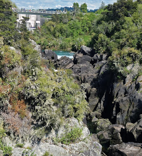
Our first destination today was a hike to Huka falls,  along the Waikato River that flows from Lake Taupo.


The falls were a bit ho hum. More like a category 4 rapids to us folks from British Columbia.


But the little hot springs we came upon as we returned to our car was a pretty nice stop to soak our much abused tootsies.


Day 12 and we are off on another short drive to the town of Tauranga where we would spend the next four days exploring the Cormandel Peninsula.


Two stops today. The first, Aratiatia Rapids, just a short drive from Taupo on the Waikato River.  At the top of the rapids is a hydro electric dam.


A couple of times a day the spill gates are fully opened filling the narrow, dry gorge with a 90,000 litres per second surge of water. This is done to maintain consistent water level for the power plant. We were in luck as we arrived just minutes before the spillways were to open so a 1000 metre dash to the viewing platform was in order to ensure we didn't miss the action. .


Hobbit fans may imagine dwarf filled barrels careening down these rapids as seen in the Desolation of Smaug, the second episode of the Hobbit trilogy. No barrels or dwarfs today. Just a hell of a lot of water.

Our drive took us past Lake Rotorua, another lake formed by the caldera of yet another volcano. Lake Rotorua is just one of 18 lakes in the area. Some of the lakes come in different colours due to the minerals that enter the lakes from all the geo-thermal activity.


There is a blue one, a green one, a yellow one and a few in between. Sadly only time for a drive by. Another reason to go back.


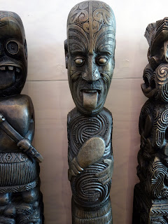
Our last stop before heading to Tauranga is Te Puia, home to a geothermal park, a Maori cultural centre and the Maori National School of Wood Carving and Weaving. arts and crafts institute.


The geothermal park is home to  what is billed as the world famous Pohutu Geyser. Not sure in what world, it was a bit under whelming at the best. Maybe it was having an off day.

The whole geothermal park was over hyped. There are several free geothermal zones in the area. I would suggest you visit them first .


Tours are  provided and delivered by Maori guides. We did learn a great deal more of  Maori history and culture so the visit was not a complete loss.


 The Maoris have suffered many of the similar fates as did our indigenous population in Canada. They are struggling to retain their cultural and the centre is helping them do that.


Friday, February 1, 2019

To Quest or Not to Quest, That is the QUESTion


The morning of Day 9 was the start our longest drive of the trip, just over 350 kilometres. The rain had moved on and a sunny day was in the forecast. Our route would take us from south end of the North Island up into its central plateau. Vistas here, were very different than those of the South Island. Brilliant green hills and fields as far as the eye can see.  The trip was made longer by a few more surprise road closures that sent the GPS into fits of “recalculating”.


We are headed for Tongariro National Park, home to three active volcanoes.  Mount Tongariro, Mount Ruapehu and Mount Ngauruhoe. Mount Ngauruhoe is the youngest of the three volcanoes, about 2500 years old.  We have traveled the world and have never missed the opportunity to climb up and/or into volcanoes. Hawaii, St. Lucia, Easter Island, Chile, Argentina, Mongolia, Italy, Canada.

Mount Ngauruhoe is kind of special. 


It is also well known as Mount Doom, the fictional volcano of Middle-Earth, where the ring was first forged and the destination of Frodo’s quest. The park was used as a location for both the Lord of the Rings and The Hobbit.  


We were here to attempt the Tongariro Crossing, a hike that would have us follow in the footsteps of Frodo in his quest to destroy the ring by throwing it the caldera of Mount Doom.


In long shots in the movie, the mountain is either a large model or a CGI effect or a combination. Filming at the summit of Ngauruhoe itself was not permitted because it is sacred to the Maori of the region. Some scenes on the slopes of Mount Doom were actually filmed on the slopes of Mount Ruapehu.


Day 10 had us waking up to a mixed bag of a day with a weather forecast of "cloudy and periods of rain". Temperature was around 2 C. Not the best weather for a quest but not the worst so it was up and outside for a 6:30 am shuttle pickup that would take us to the trail head.  The trail would have us climb 19.4 kilometres up into a high valley between Mount Tongariro and Mount Ngauruhoe, crossing two large craters with a rapid descent into a mountain forest and trails end. 


The trek is very popular, we discovered as we were joined by a hundred or so others at the trail head. According to our shuttle driver, this was just the start of the hiking season and the trail would be 20 times busier as the weather warmed up.

 The hike starts as a gentle gradient climbing beside a small stream and along the edges of old lava flows. At the head of the valley you can access Soda Springs and the area is quite boggy.


From Soda Springs, the track climbs steadily bringing us to the lip of the South Crater and a view of Yellow Lake. South Crater is not a real crater but a basin that may have been glacially carved, and has since filled with sediment from the surrounding ridges.


Down into, across and a steep climb out of the crater,


along a rocky ridge,


brought us to a view of the highest point of the Crossing, at 1866 metres, 


and some snow. 


Also a great view of the Red Crater.


More iron pyrite than I have ever seen. 


From here, there was a tricky little descent into the South Crater and the Emerald Lakes. If it had been clear, you would be able to see across the Central Crater to Blue Lake where we planned to stop for lunch. 


The Emerald Lakes are thermal. As we got closer you could see steam venting from cracks around the lake. 


After a short steep, snowy climb out of the Central Crater we arrived at Blue Lake barely visible through the fog and rain that had settle over us.    

We decided to keep moving and have lunch once the rain had stopped. It was fortuitous as it seems that the Blue Lake is tapu (sacred) and you are asked not to swim or eat food around the lake. 


From Blue Lake the trail starts to descend through golden tussock covered slopes. 


The tussock was made up of delicate grasses, plants, colorful lichen and small flowers. Very beautiful and delicate. 


The fog and rain seemed to follow us along the trail as we descended into a hardwood forest and the pick-up point for our shuttle back to the hostel.


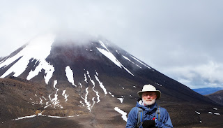
We completed the hike in 6 hours and 15 minutes. We had been talking to another couple (about our age) the night before at the hostel and they mentioned that they had done the hike in 7 hours. They seemed a bit smug about it, so we were determined to come back with a much better time than they did. You may notice we look a little smug. 

We leave tomorrow for the hot springs that abound around Lake Taupo.